The name Kush belongs to a long history of African state formation along the Nile. Its rulers, settlements and centres of power changed over time. Trade, warfare and religious exchange with Egypt repeatedly shaped that history, while Nubian communities maintained distinctive traditions and developed institutions suited to their own region.1
A river landscape of routes and boundaries
Ancient Nubia extended across parts of present-day Sudan and southern Egypt. The Nile supplied a route through it, but navigation was interrupted by rocky stretches called cataracts. Cultivable land also varied: fertile riverbanks alternated with desert and rocky ground. Gold from the surrounding deserts, alongside ivory and other goods moving through African trade networks, made the region important to Egypt. Exchanges included people as well as commodities; Nubian archers served in Egyptian armies, and Nubians also settled within Egypt.1
Kerma and the formation of a kingdom
Kerma developed into a city around 2500 BCE, near the Third Cataract. Excavations reveal a settlement whose defences changed as it expanded, with walls, bastions, trenches and controlled entrances. Houses commonly contained rectangular rooms arranged around a courtyard, with areas for kitchens and storage. The city’s eastern cemetery provides another view of its society. Burial mounds differed greatly in size, and increasingly elaborate graves contained wooden beds, vessels and personal objects. Cattle skulls placed outside tombs expressed wealth, while some large burials included people killed to accompany the principal dead person. These remains indicate pronounced differences of status and a ruling group able to command resources and labour.2
Egyptian conquest during the New Kingdom destroyed Kerma’s independent power and brought northern Nubia under Egyptian rule. The occupation endured for several centuries, approximately from the middle of the second millennium BCE to around 1070 BCE. Egyptian monuments represented conquered Nubians through hostile imagery. Everyday relationships were more varied: people traded, exchanged religious ideas and intermarried. The political inequality of occupation therefore existed alongside sustained contact between communities, leaving a substantial inheritance for the later Kushite kingdoms.3
Napata, Amun and the authority of kings
During the first millennium BCE, the Napatan region became the centre of another Kushite kingdom. At Gebel Barkal, a sandstone mountain beside the Nile, kings built temples within a landscape already sacred during the Egyptian New Kingdom. Amun, a deity worshipped in both Egypt and Kush, was associated with the mountain. Temple reliefs made that relationship visible: one scene shows Taharqa worshipping Amun seated within the mountain itself. Such imagery placed royal devotion within a recognisable sacred geography. The wider Napatan landscape included temples, palaces and cemeteries at places such as el-Kurru and Nuri. Steep-sided pyramids, painted burial chambers and funerary chapels gave lasting architectural form to kingship and the rituals surrounding royal death.4
Kushite power expanded northwards in the eighth century BCE. Piye, also known as Piankhi, campaigned in Egypt, and Kushite rulers established the dynasty conventionally numbered Egypt’s Twenty-fifth. Their authority extended across regions with different political histories, drawing on Egyptian royal traditions while retaining a Kushite base. Amun became central to royal religion, and artists adapted Egyptian forms to local purposes. Assyrian invasions in the seventh century broke Kushite control of Egypt. Taharqa withdrew south, and his successor Tanutamani briefly attempted to recover the kingdom’s northern possessions. Losing Egypt did not end Kush: its rulers continued to govern in Nubia for centuries afterwards.5
A granite sphinx of Taharqa from Kawa illustrates the language of this kingship. It combines a lion’s body with the ruler’s human head, and bears his name within a cartouche, the oval enclosure used for royal names. Two upright cobra emblems appear on his headgear. The sculpture employed an established Egyptian form associated with the sun and royal strength, while presenting a named Kushite sovereign. Burial choices also expressed the dynasty’s affiliations. Even rulers who spent much of their reigns in Egypt returned to Kush for burial near their southern religious centres.6
Meroe and its surrounding settlements
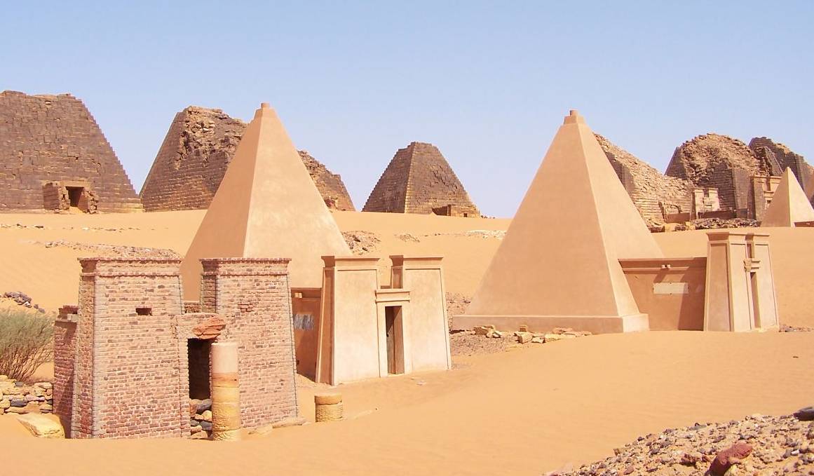
Meroe became the principal royal residence farther south, in the region between the Nile and the Atbara. From the third century BCE, most royal burials took place there. The archaeological landscape includes the city and its cemeteries together with the religious centres of Naqa and Musawwarat es-Sufra. These were different kinds of place: the royal city stood beside the river, while important temple complexes lay farther into the interior. Reservoirs and other water installations helped sustain activity beyond the immediate riverbank. Palaces, houses, temples, workshops and burial monuments show the range of work and institutions required to maintain these centres.7
Hamadab, a town a few kilometres south of Meroe, gives a closer view of urban residents. Its buildings were predominantly made of sun-dried mud brick. Excavation has mapped houses, storage facilities, industrial areas and a temple facing the main gate along a principal street. Although parts of its plan resemble fortified settlements elsewhere, its excavators interpret it chiefly as a residential town rather than a military post. Domestic quarters allow investigation of household organisation and everyday activities alongside official architecture. The temple contained monuments written in Meroitic and a bronze image of the deity Sebiumeker. Religious buildings were therefore embedded within a lived urban environment, with homes and workplaces around them.12
A written language and several religious traditions
The Meroitic period developed without a complete break from Napata, which retained religious importance. Local deities, including the lion god Apedemak, gained prominence in royal religion. A writing system also developed for the Meroitic language, using signs adapted from Egyptian scripts. It had both cursive and monumental forms. Its signs could represent a consonant with an accompanying vowel, rather than operating exactly like Egyptian hieroglyphs. Francis Llewellyn Griffith established the sound values of the signs through systematic comparison, but that achievement did not make every text translatable. Names, titles and recurring expressions can be recognised more readily than extended passages. Knowing how a sequence was pronounced is different from knowing what all its words meant.8
Production, skill and the circulation of goods
Iron production left substantial material traces around Meroe: furnace remains, charcoal, technical ceramics and mounds of slag, the waste produced during smelting. Radiocarbon research by Jane Humphris and Thomas Scheibner establishes a long sequence of production extending across more than a millennium. Some proposed early dates remain difficult to interpret because old wood or the movement of waste can complicate the dating of a deposit. Nevertheless, the evidence places ironworking well before the later Meroitic centuries and shows its continuation after central royal power declined. The size of a slag mound cannot directly reveal the quantity of finished iron: that also depends on the ore, furnace operation and efficiency. Production changed location and intensity within the developing urban landscape.10
Jewellery reveals another field of specialist work. Kushite craftspeople combined gold with stones, enamel and glass, making pendants, earrings, bracelets and other ornaments. Some materials travelled long distances, including lapis lazuli from Afghanistan, while local workshops transformed them into objects with particular social and religious meanings. Protective deities and symbols appeared on ornaments worn in life or placed with the dead. Elaborate jewellery accompanied royal women buried at el-Kurru, and later Meroitic rulers were shown wearing layers of adornment. Objects with similarities to Greek jewellery were once treated as imports; scientific examination has identified local manufacture in some cases. A foreign-looking design could thus reflect the choices of Kushite makers.9
War and negotiation on the Roman frontier
When Rome controlled Egypt, the northern frontier became a zone of armed conflict. The Greek geographer Strabo describes Kushite forces taking Syene, Elephantine and Philae, carrying away captives and pulling down imperial statues. His account then celebrates the victories of the Roman commander Petronius, including an attack on Napata. It also records a queen directing resistance and sending envoys. Captives were enslaved during the fighting, showing the human cost of the campaigns on both sides. The conflict ended in negotiation: according to Strabo, envoys reached Augustus on Samos and obtained the remission of imposed tribute. Even within this Roman-centred narrative, military success did not simply translate into the permanent submission of Kush to imperial government.11
Political fragmentation and a changing environment
Centralised Meroitic rule dissolved around the fourth century CE, with smaller political formations emerging across its former territory. The causes remain debated. Research on human and animal teeth from thirteen cemeteries has added environmental evidence to explanations concerned with political and economic instability. Changing carbon and oxygen isotope values indicate dietary changes and increasingly dry conditions. Consumption shifted towards crops such as sorghum and millet, which were better suited to drier environments than wheat and barley. These findings suggest pressures on farming, water and land use that may have contributed to political transformation. They support a history of interacting changes rather than a single sudden event that explains every region’s experience.13
The modern interpretation of these kingdoms has itself changed. George Reisner’s early twentieth-century excavations produced extensive records, but his racial assumptions distorted his conclusions. An Egyptian statue found in a Kerma royal tomb helped persuade him that Egyptians had ruled the city. Later interpretation instead recognised that Egyptian objects could have reached an independent Kerma through raids and other exchanges. The same find thus acquired a different place in the history of Kush as the political assumptions surrounding it were reconsidered.3
Sources and further reading
1. The Land of Nubia — The Metropolitan Museum of Art.
2. Kerma: city and necropolis — Swiss Archaeological Mission at Kerma.
3. Ancient Nubia Now: history and interpretation — Museum of Fine Arts, Boston.
4. Gebel Barkal and the Sites of the Napatan Region — UNESCO World Heritage Centre.
5. Sudan, 1000 B.C.–1 A.D. — The Metropolitan Museum of Art.
6. Sphinx of Taharqo — British Museum; Google Arts & Culture.
7. Archaeological Sites of the Island of Meroe — UNESCO World Heritage Centre.
8. The Meroitic Language and Writing System: introduction — Claude Rilly and Alex de Voogt; Cambridge University Press.
9. Gold and the Gods: Jewels of Ancient Nubia — Museum of Fine Arts, Boston.
10. A New Radiocarbon Chronology for Ancient Iron Production in the Meroe Region of Sudan — Jane Humphris and Thomas Scheibner; African Archaeological Review.
11. Geography, 17.1.54 — Strabo, translated by H. L. Jones; ASOR.
12. Meroitic Urbanism and Settlement Patterns: Discoveries from Hammadab — Abdelmonim Ahmed Abdalla Babiker; University of Khartoum.
13. Isotopic evidence of an environmental shift at the fall of the Kushite kingdom of Meroë, Sudan — Iwona Kozieradzka-Ogunmakin and Arkadiusz Sołtysiak; Antiquity.
Featured image. Pyramids at Meroe in Sudan, photographed on 30 September 2005. This is a modern view of the archaeological site. Photograph: Fabrizio Demartis, 30 September 2005, via Wikimedia Commons; source-provided crop. Image record · CC BY-SA 2.0
